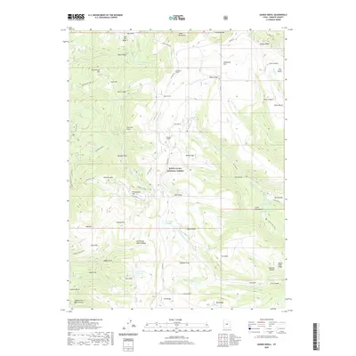
2020 Map of Danish Knoll
USGS Topo · Published 2020About this map
Manti-La Sal National Forest dominates this section of the Wasatch Plateau, where a complex system of hydraulic engineering defines the high-altitude landscape. Notable features include the Larson Tunnel, Horseshoe Tunnel, and Ephraim Tunnel, which alongside the Wasatch Ditch and Madsen Ditch, represent a significant historical effort to manage water resources across the mountain divide. These man-made diversions connect various natural and artificial basins such as John August Lake, New Canyon Reservoir, and Little Petes Hole Reservoir. The terrain is marked by distinctive named heights like Danish Knoll, Haystack Mtn, and Dusterburgs Hill, while the Josephite Pt Trail and Skyline Dr provide access through the dense network of canyons and flats, including Philadelphia Flat and Bluebell Flat.
Find a feature on this map
80 named features on this map. Tap any name to fly to it.
Don’t see what you’re looking for? This feature index may not catch every label — zoom into the map to look around manually.
Map Details
Editions of this 2020 Danish Knoll Map
This is the sole edition of this map. No revisions or reprints were ever made.
Other maps of this area

1885 · Manti
USGS Topo · 1:250,000

1895 · Manti
USGS Topo · 1:250,000

1922 · Wasatch
USGS Topo · 1:31,680

1956 · Price
USGS Topo · 1:250,000

1960 · Price
USGS Topo · 1:250,000

1962 · Price
USGS Topo · 1:250,000

1965 · Black Mountain
USGS Topo · 1:24,000
1966 · Ferron Reservoir
USGS Topo · 1:24,000

1966 · Spring City
USGS Topo · 1:24,000

1966 · Chester
USGS Topo · 1:24,000