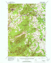
1956 Map of Dannemora
USGS Topo · Published 1960About this map
Dannemora and its institutional landscape dominate the northwest corner of this mid-century survey, characterized by the State Prison Cem and the State Prison and Hospital Cem. The Saranac River carves a path through the center of the quadrangle, fueling industry at Woods Mills and Cadyville while supporting the Delaware and Hudson railroad line. To the south, the terrain rises into the Adirondacks, marked by Mitchell Mtn and Mt Etna, where the Mother Cabrini Shrine sits near the Adirondack State Park Boundary.
Find a feature on this map
70 named features on this map. Tap any name to fly to it.
Don’t see what you’re looking for? This feature index may not catch every label — zoom into the map to look around manually.
Map Details
Editions of this 1956 Dannemora Map
3 editions found
Other maps of this area

1894 · Plattsburg
USGS Topo · 1:62,500

1895 · Mooers
USGS Topo · 1:62,500

1895 · Rouse Point
USGS Topo · 1:62,500

1895 · Willsboro
USGS Topo · 1:62,500

1895 · Ausable
USGS Topo · 1:62,500

1896 · Lake Placid
USGS Topo · 1:62,500

1898 · Lake Placid
USGS Topo · 1:62,500

1899 · Mooers
USGS Topo · 1:62,500

1903 · Ausable
USGS Topo · 1:62,500

1906 · Plattsburg
USGS Topo · 1:62,500