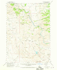
1960 Map of Danskin Peak
USGS Topo · Published 1970About this map
South Fork Boise River cuts a deep path through this section of the Boise Ridge, where high plateaus like Smith Prairie meet a network of steep gulches and creeks. At the start of the 1960s, the area's infrastructure supported fire prevention and land management, centered around the Danskin Guard Station and the high-altitude Danskin Peak Lookout. To the south, the Long Tom Reservoir and the Long Tom Ranch represent the localized water management and ranching interests in this corner of Elmore County.
Find a feature on this map
91 named features on this map. Tap any name to fly to it.
Don’t see what you’re looking for? This feature index may not catch every label — zoom into the map to look around manually.
Map Details
Editions of this 1960 Danskin Peak Map
3 editions found

Other maps of this area

1892 · Mountain Home
USGS Topo · 1:125,000

1892 · Camas Prairie
USGS Topo · 1:125,000

1893 · Mountain Home
USGS Topo · 1:125,000

1893 · Camas Prairie
USGS Topo · 1:125,000

1894 · Idaho Basin
USGS Topo · 1:125,000

1894 · Rocky Bar
USGS Topo · 1:125,000

1955 · Hailey
USGS Topo · 1:250,000

1956 · Crater Rings
USGS Topo · 1:24,000

1956 · Mountain Home North
USGS Topo · 1:24,000

1956 · Mountain Home
USGS Topo · 1:62,500