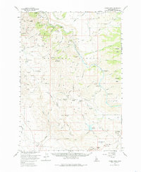
1960 Map of Danskin Peak
USGS Topo · Published 1985About this map
Smith Prairie dominates the northern landscape of this Idaho interior, where the Boise River South Fork carves a deep path through the Boise National Forest. Surveyed in 1960, the region is defined by its transition from high plateaus like Ballingers Flat and Cougar Flat to the prominent heights of Danskin Peak and House Mtn. The map documents a remote infrastructure of forest management and ranching, evidenced by the Danskin Guard Sta and the Long Tom Ranch. A network of primitive routes, including the Lava Trail and various jeep trails, connect isolated water sources such as Little Fiddler Creek and Mud Spring Creek. This survey captures the drainage patterns toward the Long Tom Reservoir and the Spillway 4418 at a time when the area's geography was primarily shaped by cattle ranching and federal forestry efforts.
Find a feature on this map
89 named features on this map. Tap any name to fly to it.
Don’t see what you’re looking for? This feature index may not catch every label — zoom into the map to look around manually.
Map Details
Editions of this 1960 Danskin Peak Map
3 editions found

Other maps of this area

1892 · Mountain Home
USGS Topo · 1:125,000

1892 · Camas Prairie
USGS Topo · 1:125,000

1893 · Mountain Home
USGS Topo · 1:125,000

1893 · Camas Prairie
USGS Topo · 1:125,000

1894 · Idaho Basin
USGS Topo · 1:125,000

1894 · Rocky Bar
USGS Topo · 1:125,000

1955 · Hailey
USGS Topo · 1:250,000

1956 · Crater Rings
USGS Topo · 1:24,000

1956 · Mountain Home North
USGS Topo · 1:24,000

1956 · Mountain Home
USGS Topo · 1:62,500