Loading...
Loading map...1953 Map of Danville
USGS Topo · Published 1973About this map
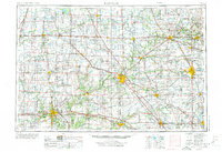
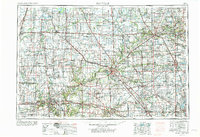
Danville and the Vermilion River valley anchor this mid-century portrait of the Illinois-Indiana borderlands. This 1:250,000 scale survey, revised in the early 1970s, documents a landscape where agricultural commerce and heavy rail intersect. Large water bodies like Lake Shafer and Lake Freeman on the Tippecanoe River reflect the region's managed waterways, while Kickapoo State Park and Lake Vermilion provide recreational contrast to the industrial corridors surrounding the larger towns.
Find a feature on this map
103 named features on this map. Tap any name to fly to it.
Don’t see what you’re looking for? This feature index may not catch every label — zoom into the map to look around manually.
Map Details
Date Portrayed1953
Date Published1973
PublisherU.S. Geological Survey
Map TypeTopographic
Scale1:250,000
Physical Dimensions32.1 x 22 inches
Editions of this 1953 Danville Map

Historical Maps of Carmel Through Time
7 maps found


Featured Locations
Source Details
SourceU.S. Geological Survey
CopyrightPublic Domain