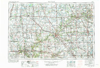
1953 Map of Danville
USGS Topo · Published 1973About this map
The Wabash River valley serves as the central artery for this mid-century portrait of Western Indiana and Eastern Illinois, anchoring a landscape defined by collegiate centers and industrial growth. Academic institutions like Purdue University in Lafayette and Wabash College in Crawfordsville stand alongside major manufacturing and transportation hubs. To the west, the coal fields around Danville and Westville are marked by an intensive Strip mine economy, while the presence of Grissom Air Force Base near Peru reflects the era's Cold War military footprint.
Find a feature on this map
59 named features on this map. Tap any name to fly to it.
Don’t see what you’re looking for? This feature index may not catch every label — zoom into the map to look around manually.
Map Details
Editions of this 1953 Danville Map

Other maps of this area

1899 · Danville
USGS Topo · 1:62,500

1900 · Danville
USGS Topo · 1:62,500

1906 · Urbana
USGS Topo · 1:62,500

1922 · Momence
USGS Topo · 1:62,500

1922 · Kankakee
USGS Topo · 1:62,500

1923 · Herscher
USGS Topo · 1:62,500

1924 · Momence
USGS Topo · 1:62,500

1924 · Kankakee
USGS Topo · 1:62,500

1924 · Paxton
USGS Topo · 1:62,500

1925 · Herscher
USGS Topo · 1:62,500