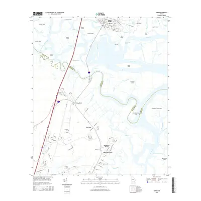
2014 Map of Darien
USGS Topo · Published 2014About this map
Darien sits at the head of a complex delta system where the Altamaha River fractures into a network of distributaries including the Butler River, Champney River, and Darien River. This landscape is defined by its coastal geography, featuring a mosaic of marsh islands like Butler Island and Generals Island separated by narrow passages such as Generals Cut and Pico Cut. The settlement pattern reflects deep-rooted local history, particularly visible through the identification of the Old Slave Cem and Freedman Cem, which provide significant genealogical touchpoints for the region's heritage. To the south, the development transition is marked by residential clusters like Oglethorpe Manor and North End, leading toward the Brunswick Golden Isles Airport. The intricate waterways, from the Intracoastal Waterway to Fridaycap Creek, demonstrate the enduring reliance on this river-and-marsh environment for both transportation and the local economy.
Find a feature on this map
132 named features on this map. Tap any name to fly to it.
Don’t see what you’re looking for? This feature index may not catch every label — zoom into the map to look around manually.
Map Details
Editions of this 2014 Darien Map
This is the sole edition of this map. No revisions or reprints were ever made.
Other maps of this area

1918 · Everett City
USGS Topo · 1:62,500

1918 · Bladen
USGS Topo · 1:62,500

1920 · Everett City
USGS Topo · 1:62,500

1921 · Darien
USGS Topo · 1:62,500

1939 · Bladen
USGS Topo · 1:62,500

1944 · Everett City
USGS Topo · 1:62,500

1945 · Brunswick
USGS Topo · 1:62,500

1946 · Brunswick
USGS Topo · 1:250,000

1948 · Brunswick
USGS Topo · 1:250,000

1954 · Altamaha Sound
USGS Topo · 1:24,000