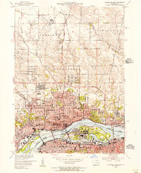
1953 Map of Davenport East
USGS Topo · Published 1956About this map
The Mississippi River serves as the central artery for this mid-century quadrangle, defining the border between Iowa and Illinois as it flows past the Rock Island Arsenal. This map captures the industrial and civic heart of the Quad Cities, detailing the urban expansion of Davenport and Bettendorf on the northern bank, while Rock Island and Moline sit to the south. The river infrastructure is prominent, notably Lock and Dam No 15 and the Municipal Terminal at Davenport Harbor.
Find a feature on this map
80 named features on this map. Tap any name to fly to it.
Don’t see what you’re looking for? This feature index may not catch every label — zoom into the map to look around manually.
Map Details
Editions of this 1953 Davenport East Map
Other maps of this area

1891 · Davenport
USGS Topo · 1:62,500

1892 · Leclaire
USGS Topo · 1:62,500

1893 · Leclaire
USGS Topo · 1:62,500

1894 · Davenport
USGS Topo · 1:62,500

1899 · Clinton
USGS Topo · 1:125,000

1901 · Rock Island
USGS Topo · 1:125,000

1910 · Rock Island
USGS Topo · 1:125,000

1912 · Milan
USGS Topo · 1:62,500

1937 · Orion
USGS Topo · 1:62,500

1944 · Milan
USGS Topo · 1:62,500