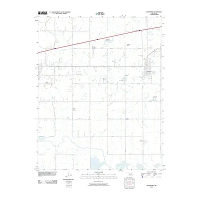
2009 Map of Davenport
USGS Topo · Published 2009About this map
The town of Davenport serves as a central hub in this Lincoln County landscape, situated near the intersection of various local routes and the waters of Chuckaho Creek. The terrain is defined by its water management and agricultural drainage, featuring significant local landmarks like Lake Davenport, A C M Lake, and the uniquely named Oknoname 08107 Reservoir. To the south, the Deep Fork river winds through the territory, creating a distinct floodplain area contrasting with elevations such as Gobblers Knob. Genealogists will find considerable value in the distribution of rural burial grounds throughout the quadrangle, including the Cardwell Cemetery, Morning Star Cemetery, Dunkard Cemetery, and Booker Cemetery. This 2009 survey also documents local aviation infrastructure at the Chandler Municipal Airport and smaller named locales like Daggett and Clematis.
Find a feature on this map
39 named features on this map. Tap any name to fly to it.
Don’t see what you’re looking for? This feature index may not catch every label — zoom into the map to look around manually.
Map Details
Editions of this 2009 Davenport Map
This is the sole edition of this map. No revisions or reprints were ever made.
Other maps of this area

1905 · Chandler
USGS Topo · 1:62,500

1907 · Chandler
USGS Topo · 1:62,500

1908 · Agra
USGS Topo · 1:62,500

1929 · Stroud
USGS Topo · 1:62,500

1931 · Drumright
USGS Topo · 1:62,500

1932 · Stroud
USGS Topo · 1:62,500

1954 · Oklahoma City
USGS Topo · 1:250,000

1957 · Oklahoma City
USGS Topo · 1:250,000

1963 · Oklahoma City
USGS Topo · 1:250,000
1974 · Arlington
USGS Topo · 1:24,000