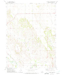
1972 Map of Davenport Table
USGS Topo · Published 1975About this map
Pleasant Hill anchors the northern high ground of this Custer County landscape, where the plateau surface of West Table begins its descent into a complex network of erosional breaks. The topography is defined by sharp contrasts between the flat agricultural reaches of Davenport Table and the steep, intricate drainages of Lower Powell Canyon, Hidden Valley, and Pine Canyon. These landforms dictate the local movement of water toward the South Loup River in the south, where the terrain finally levels out.
Find a feature on this map
14 named features on this map. Tap any name to fly to it.
Don’t see what you’re looking for? This feature index may not catch every label — zoom into the map to look around manually.
Map Details
Editions of this 1972 Davenport Table Map
This is the sole edition of this map. No revisions or reprints were ever made.
Other maps of this area

1948 · Linscott
USGS Topo · 1:62,500

1950 · Linscott
USGS Topo · 1:62,500

1951 · Callaway NW
USGS Topo · 1:24,000

1951 · Anselmo SW
USGS Topo · 1:24,000

1951 · Callaway
USGS Topo · 1:24,000

1954 · North Platte
USGS Topo · 1:250,000

1955 · Broken Bow
USGS Topo · 1:250,000

1956 · Broken Bow
USGS Topo · 1:250,000

1956 · North Platte
USGS Topo · 1:250,000

1957 · North Platte
USGS Topo · 1:250,000