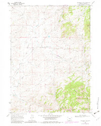
1968 Map of Davidson Flats
USGS Topo · Published 1982About this map
Davidson Flats defines this portion of Albany County, where the high prairie terrain transitions into the wooded slopes of the Medicine Bow National Forest. The landscape is a network of drainage systems including North Creek, Siebolt Creek, and the West Branch McFarlane Creek, which carve through the open range and draws like Wallace Draw and Mertz Draw. Local landmarks such as Britania Mountain, Pine Mountain, and the distinctive Split Rock anchor the topography, while the presence of a Landing Strip and various wells suggests the intersection of traditional ranching with mid-century utility. In the southeastern corner, the sudden drop at Duck Creek Falls provides a rare point of vertical relief before the waters of Duck Creek exit the quadrangle. This 1968 survey, updated in the early 1980s, captures a snapshot of the region's cattle-country character before modern development.
Find a feature on this map
23 named features on this map. Tap any name to fly to it.
Don’t see what you’re looking for? This feature index may not catch every label — zoom into the map to look around manually.
Map Details
Editions of this 1968 Davidson Flats Map
3 editions found
Other maps of this area

1954 · Torrington
USGS Topo · 1:250,000

1954 · Cheyenne
USGS Topo · 1:250,000

1955 · Dodge Ranch
USGS Topo · 1:24,000

1955 · Moonshine Peak
USGS Topo · 1:24,000

1955 · Bull Camp Peak
USGS Topo · 1:24,000

1958 · Cheyenne
USGS Topo · 1:250,000

1958 · Torrington
USGS Topo · 1:250,000

1968 · Cow Creek Mountain
USGS Topo · 1:24,000

1968 · Davidson Flats
USGS Topo · 1:24,000
1968 · Reese Mountain
USGS Topo · 1:24,000