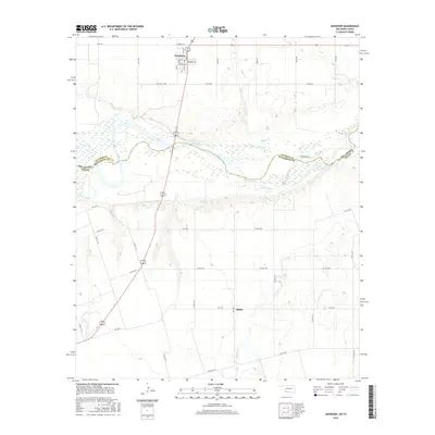
2016 Map of Davidson
USGS Topo · Published 2016About this map
Davidson sits at the northern edge of this borderland landscape, where the street grid of Central Ave and N Main St serves as a small pocket of development in an area otherwise defined by wide river bottoms and rural tracts. The Red River carves a broad, braided path across the center of the sheet, acting as the natural boundary between Oklahoma and Texas. This geography creates a distinct division between the grid-patterned sections of Tillman Co to the north and the road network of Wilbarger Co to the south. Small watercourses like Bottle Cr and Adams Cr drain toward the river, while the settlement of Elliott marks a crossroads in the southern half of the quadrangle. The map reveals the relationship between the agricultural road system, including routes like Oklahoma Rd and Weaver Rd, and the shifting sands of the river valley.
Find a feature on this map
38 named features on this map. Tap any name to fly to it.
Don’t see what you’re looking for? This feature index may not catch every label — zoom into the map to look around manually.
Map Details
Editions of this 2016 Davidson Map
This is the sole edition of this map. No revisions or reprints were ever made.
Other maps of this area

1916 · Electra
USGS Topo · 1:24,000

1918 · Electra
USGS Topo · 1:31,680

1955 · Lawton
USGS Topo · 1:250,000

1958 · Davidson
USGS Topo · 1:62,500

1958 · Frederick
USGS Topo · 1:62,500

1958 · Electra
USGS Topo · 1:62,500
1972 · Electra
USGS Topo · 1:24,000

1974 · Hackberry Flat
USGS Topo · 1:24,000

1975 · Frederick SW
USGS Topo · 1:24,000

1975 · Frederick SE
USGS Topo · 1:24,000