
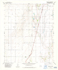
1975 Map of Frederick SE
USGS Topo · Published 1975About this map
The agricultural grid of Tillman County dominates this 1975 orthophoto, where the landscape is meticulously carved into geometric plots of farmland. This aerial perspective, captured by the U.S. Geological Survey using photographs from February of that year, highlights the expansive nature of the Oklahoma plains. In the northeast corner, the Frederick Municipal Airport stands as a significant local hub, its runways and structures clearly visible against the surrounding fields. The meandering path of Suttle Creek provides a natural contrast to the rigid human-made boundaries of the terrain, winding through the center-east of the sheet. For those studying land use or regional development, this view provides a precise record of the irrigation and road networks established during the mid-1970s.
Find a feature on this map
2 named features on this map. Tap any name to fly to it.
Don’t see what you’re looking for? This feature index may not catch every label — zoom into the map to look around manually.
Map Details
Editions of this 1975 Frederick SE Map
This is the sole edition of this map. No revisions or reprints were ever made.
Other maps of this area

1955 · Lawton
USGS Topo · 1:250,000

1958 · Davidson
USGS Topo · 1:62,500

1958 · Frederick
USGS Topo · 1:62,500

1958 · Electra
USGS Topo · 1:62,500

1974 · Hollister NW
USGS Topo · 1:24,000

1974 · Hackberry Flat
USGS Topo · 1:24,000

1975 · Frederick NE
USGS Topo · 1:24,000

1975 · Frederick SW
USGS Topo · 1:24,000

1975 · Frederick NW
USGS Topo · 1:24,000
1984 · Frederick SE
USGS Topo · 1:24,000