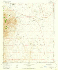
1955 Map of Davies Tank
USGS Topo · Published 1962About this map
The Organ Mountains dominate the western edge of this mid-century survey, their steep slopes giving way to a landscape defined by strategic defense and desert water management. The vast White Sands Proving Ground and the Fort Bliss Military Reservation occupy the majority of the terrain, meeting at a prominent Military Reservation Boundary that bisects the central desert. For those researching the military's footprint in New Mexico during the Cold War era, the presence of the Condron Air Force Auxiliary Field provides a specific point of operational history. Scattered water sources such as Davies Tank, Gooding Well, and Globe Spring reveal how the arid basin was managed for range or remote outposts before and during the establishment of these restricted zones, while the small settlements of White Sands and Glendale mark the fringes of human habitation.
Find a feature on this map
21 named features on this map. Tap any name to fly to it.
Don’t see what you’re looking for? This feature index may not catch every label — zoom into the map to look around manually.
Map Details
Editions of this 1955 Davies Tank Map
3 editions found
Other maps of this area

1891 · Las Cruces
USGS Topo · 1:125,000

1893 · Las Cruces
USGS Topo · 1:125,000

1940 · Newman
USGS Topo · 1:62,500

1941 · Organ Peak
USGS Topo · 1:62,500

1943 · La Mesa
USGS Topo · 1:62,500

1943 · Parker Lake
USGS Topo · 1:62,500

1943 · Newman
USGS Topo · 1:62,500

1943 · Organ Peak
USGS Topo · 1:62,500

1948 · Davies Tank
USGS Topo · 1:24,000

1948 · Newman NW
USGS Topo · 1:24,000