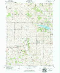
1971 Map of Davis
USGS Topo · Published 1974About this map
The village of Davis and the nearby settlement of Rock City anchor this landscape along the border of Illinois and Wisconsin in the early 1970s. The region is defined by a mix of agricultural tradition and new recreational developments, most notably the residential layout around Lake Summerset in the northeast. Transportation and trade are tied to the Chicago Milwaukee St Paul and Pacific railroad, which runs east-west through the heart of the area, passing through Epplyanna and Rock City. Several small rural burial grounds, including Pioneers Cem and Bethlehem Cem, are preserved near family-named landmarks like St Pauls Ch. The terrain transitions from the winding course of Rock Run to the upland plateaus where numerous quarries and a Gravel Pit indicate a local economy supported by mineral extraction.
Find a feature on this map
64 named features on this map. Tap any name to fly to it.
Don’t see what you’re looking for? This feature index may not catch every label — zoom into the map to look around manually.
Map Details
Editions of this 1971 Davis Map
This is the sole edition of this map. No revisions or reprints were ever made.
Other maps of this area

1893 · Brodhead
USGS Topo · 1:62,500

1920 · Monroe
USGS Topo · 1:62,500

1922 · Monroe
USGS Topo · 1:62,500

1932 · Pecatonica
USGS Topo · 1:62,500

1936 · Pecatonica
USGS Topo · 1:62,500

1939 · Freeport
USGS Topo · 1:48,000

1944 · Freeport
USGS Topo · 1:62,500

1954 · Rockford
USGS Topo · 1:250,000

1955 · Rockford
USGS Topo · 1:250,000

1958 · Rockford
USGS Topo · 1:250,000