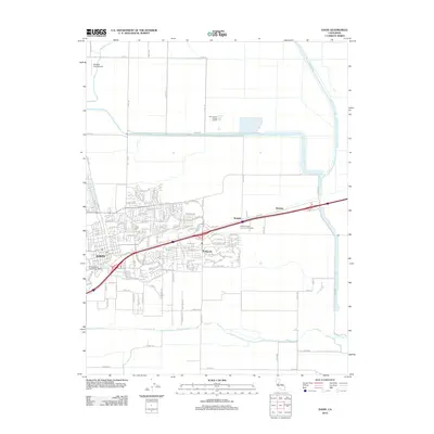
2012 Map of Davis
USGS Topo · Published 2012About this map
The University of California - Davis dominates the southwestern corner of this survey, illustrating the extensive footprint of the institution within the community of Davis. The landscape transition is evident between the organized street grid of the city and the suburban development of El Macero to the southeast. To the east, the small settlements of Swingle and Webster sit along the transportation corridor, while the State Nursery Division of Forestry is situated nearby. The northern reaches of the map are defined by agricultural infrastructure and water management, featuring the Willow Slough Bypass and the Yolo County Central Landfill. Hydrological features like Putah Cr and the S Fork Putah Cr provide a natural boundary to the south, while Medlock Field Airport occupies a clearing in the northwest, reflecting the area's mix of academic, residential, and rural utility.
Find a feature on this map
133 named features on this map. Tap any name to fly to it.
Don’t see what you’re looking for? This feature index may not catch every label — zoom into the map to look around manually.
Map Details
Editions of this 2012 Davis Map
This is the sole edition of this map. No revisions or reprints were ever made.
Other maps of this area

1907 · Woodland
USGS Topo · 1:62,500

1907 · Davisville
USGS Topo · 1:62,500

1908 · Vacaville
USGS Topo · 1:62,500

1908 · Courtland
USGS Topo · 1:62,500

1915 · Yolo
USGS Topo · 1:31,680

1915 · Swingle
USGS Topo · 1:31,680
1915 · Elkhorn Weir
USGS Topo · 1:31,680

1915 · Merritt
USGS Topo · 1:31,680

1916 · Dixon
USGS Topo · 1:31,680

1916 · Grays Bend
USGS Topo · 1:31,680