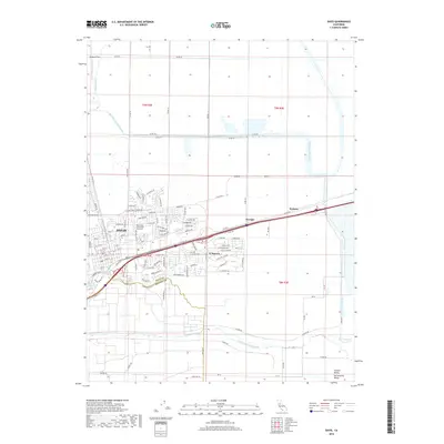
2018 Map of Davis
USGS Topo · Published 2018About this map
Davis and its surrounding agricultural and suburban landscape are clearly defined in this 2018 survey, which shows the city's interface with the Sacramento Valley. The map detail follows the transition from the dense street grid and academic spaces near Lake Spafford to the planned residential layout of El Macero. Water management is a dominant theme, with the engineered Willow Slough Bypass and the meandering course of Putah Cr shaping the regional topography.
Find a feature on this map
103 named features on this map. Tap any name to fly to it.
Don’t see what you’re looking for? This feature index may not catch every label — zoom into the map to look around manually.
Map Details
Editions of this 2018 Davis Map
This is the sole edition of this map. No revisions or reprints were ever made.
Other maps of this area

1907 · Woodland
USGS Topo · 1:62,500

1907 · Davisville
USGS Topo · 1:62,500

1908 · Vacaville
USGS Topo · 1:62,500

1908 · Courtland
USGS Topo · 1:62,500

1915 · Yolo
USGS Topo · 1:31,680

1915 · Swingle
USGS Topo · 1:31,680
1915 · Elkhorn Weir
USGS Topo · 1:31,680

1915 · Merritt
USGS Topo · 1:31,680

1916 · Dixon
USGS Topo · 1:31,680

1916 · Grays Bend
USGS Topo · 1:31,680