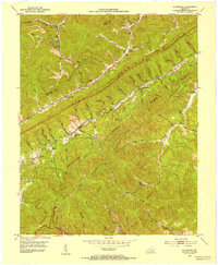
1952 Map of Davisburg
USGS Topo · Published 1954About this map
Pine Mountain and Log Mountain dominate this corner of the Cumberland Plateau, where the ridges of the Kentucky State Forest define the high ground. The Louisville and Nashville railroad tracks follow the winding path of Brush Creek through the north, serving the small coal-town settlements of Kayjay and Wheeler. This 1952 snapshot of the Bell and Knox county line shows a landscape deeply shaped by the extraction economy, with a Tramway and numerous local schools like Davisburg Sch and Centennial Sch positioned to serve isolated hollows. Several family burying grounds, including the Old Carroll Cem and Fuson Chapel Cem, are tucked into the steep drainages of Clear Fork and Greasy Branch. These local landmarks, along with the Lookout Tower on Pine Mountain, offer researchers an exact record of the area's mid-century rural infrastructure.
Find a feature on this map
82 named features on this map. Tap any name to fly to it.
Don’t see what you’re looking for? This feature index may not catch every label — zoom into the map to look around manually.
Map Details
Editions of this 1952 Davisburg Map
This is the sole edition of this map. No revisions or reprints were ever made.
Other maps of this area

1886 · Cumberland Gap
USGS Topo · 1:125,000

1888 · Cumberland Gap
USGS Topo · 1:125,000

1891 · Cumberland Gap
USGS Topo · 1:125,000

1903 · Pineville
USGS Topo · 1:48,000

1903 · Middlesboro
USGS Topo · 1:48,000

1927 · Middlesboro
USGS Topo · 1:62,500

1930 · Middlesboro
USGS Topo · 1:62,500

1935 · Mingo Mountains
USGS Topo · 1:24,000

1935 · Cumberland Gap
USGS Topo · 1:24,000
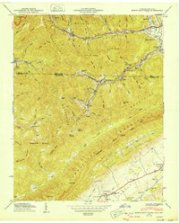
1950 · Mingo Mountains
USGS Topo · 1:24,000