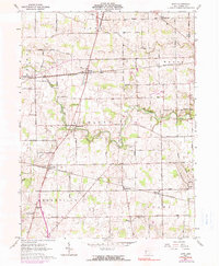
1961 Map of Dawn
USGS Topo · Published 1990About this map
Richland and Greenville townships form the heart of this rural landscape, where the winding course of the Stillwater River dictates the local geography. In the early 1960s, the Penn Central railroad served as a vital transport corridor, connecting the small agrarian hubs of Dawn, Pikeville, Stelvideo, and Horatio. These settlements, often centered on rail sidings or road junctions, reflect the enduring agricultural character of Darke County.
Find a feature on this map
94 named features on this map. Tap any name to fly to it.
Don’t see what you’re looking for? This feature index may not catch every label — zoom into the map to look around manually.
Map Details
Editions of this 1961 Dawn Map
3 editions found
Other maps of this area

1908 · St. Henry
USGS Topo · 1:62,500

1909 · Loramie
USGS Topo · 1:62,500

1911 · Loramie
USGS Topo · 1:62,500

1911 · Covington
USGS Topo · 1:62,500

1944 · Covington
USGS Topo · 1:62,500

1944 · Loramie
USGS Topo · 1:62,500

1953 · Muncie
USGS Topo · 1:250,000

1956 · Muncie
USGS Topo · 1:250,000

1961 · Dawn
USGS Topo · 1:24,000
1961 · Greenville East
USGS Topo · 1:24,000