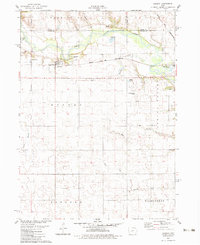
1982 Map of Dawson
USGS Topo · Published 1983About this map
The North Raccoon River and the Raccoon River converge amidst a landscape of agricultural sections and meandering tributaries in the early 1980s. The town of Dawson serves as a local hub along the Chicago and North Western railroad line, which cuts through the northern half of the region. Local recreational and utility features, such as Sportsmens Park and the Perry Municipal Airport, reflect the community infrastructure of this Iowa river valley. Geologic and industrial activity is evidenced by a Sand and Gravel Pit near the riverbanks. For genealogists, the map identifies several burial sites including Angus Cem, Township Cems, and Valleyview Cem, providing clear spatial context for local family histories near the borders of Dallas, Greene, and Boone Counties.
Find a feature on this map
28 named features on this map. Tap any name to fly to it.
Don’t see what you’re looking for? This feature index may not catch every label — zoom into the map to look around manually.
Map Details
Editions of this 1982 Dawson Map
This is the sole edition of this map. No revisions or reprints were ever made.
Other maps of this area

1949 · Adel
USGS Topo · 1:62,500

1950 · Perry
USGS Topo · 1:62,500

1951 · Perry
USGS Topo · 1:62,500

1951 · Adel
USGS Topo · 1:62,500

1952 · Panora
USGS Topo · 1:62,500

1954 · Bagley
USGS Topo · 1:62,500

1954 · Omaha
USGS Topo · 1:250,000

1957 · Omaha
USGS Topo · 1:250,000

1958 · Omaha
USGS Topo · 1:250,000
1982 · Rippey
USGS Topo · 1:24,000