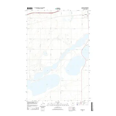
2014 Map of Dawson
USGS Topo · Published 2014About this map
Dawson sits along the northern edge of this Kidder County landscape, positioned at a vital junction where the southern prairie meets a chain of significant water bodies. The terrain is defined by the expansive basins of Alkali Lake, Lake Etta, and Lake Isabel, which dominate the central and eastern portions of the map. These lakes, separated by subtle rises in elevation, suggest a drainage pattern characteristic of the glaciated plains. A geometric grid of local township roads, such as 43rd St SE and 31st Ave SE, crisscrosses the open country, providing access to the agricultural lands and lakefronts. The presence of Nd-3 and Interstate 94 indicates the area's role as a transit corridor connecting small prairie settlements. This 2014 survey records the modern infrastructure overlaying a landscape still largely shaped by its natural hydrology and the early settlement patterns of central North Dakota.
Find a feature on this map
24 named features on this map. Tap any name to fly to it.
Don’t see what you’re looking for? This feature index may not catch every label — zoom into the map to look around manually.
Map Details
Editions of this 2014 Dawson Map
This is the sole edition of this map. No revisions or reprints were ever made.
Other maps of this area

1952 · Tappen South
USGS Topo · 1:24,000

1952 · Dawson
USGS Topo · 1:24,000

1952 · Tappen North
USGS Topo · 1:24,000

1952 · Steele NE
USGS Topo · 1:24,000

1952 · Steele
USGS Topo · 1:24,000

1952 · Steele NW
USGS Topo · 1:24,000

1953 · Jamestown
USGS Topo · 1:250,000

1956 · Jamestown
USGS Topo · 1:250,000
1975 · Tappen North
USGS Topo · 1:24,000

1979 · Kintyre NE
USGS Topo · 1:24,000