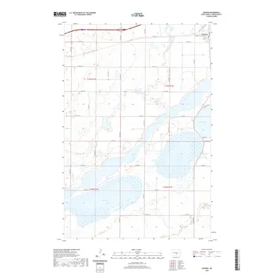
2020 Map of Dawson
USGS Topo · Published 2020About this map
Dawson sits at the northern edge of this Kidder County landscape, serving as a focal point for the surrounding prairie and wetlands. The topography is dominated by a chain of significant water bodies, most notably Alkali Lake to the south and the interconnected basins of Lake Isabel and Lake Etta. These lakes characterize the regional drainage pattern, with marshy fringes and fluctuating shorelines typical of the North Dakota plains. A grid of section roads, including Co Hwy 10 and numbered streets like 40th St SE, provides access to the agricultural tracts between the water. Near the shores of Lake Isabel, residential developments are evident through labels like N Lakeview Dr and Sunset Dr, suggesting the lake's importance for local recreation and lakeside living in this rural township.
Find a feature on this map
22 named features on this map. Tap any name to fly to it.
Don’t see what you’re looking for? This feature index may not catch every label — zoom into the map to look around manually.
Map Details
Editions of this 2020 Dawson Map
This is the sole edition of this map. No revisions or reprints were ever made.
Other maps of this area

1952 · Tappen South
USGS Topo · 1:24,000

1952 · Dawson
USGS Topo · 1:24,000

1952 · Tappen North
USGS Topo · 1:24,000

1952 · Steele NE
USGS Topo · 1:24,000

1952 · Steele
USGS Topo · 1:24,000

1952 · Steele NW
USGS Topo · 1:24,000

1953 · Jamestown
USGS Topo · 1:250,000

1956 · Jamestown
USGS Topo · 1:250,000
1975 · Tappen North
USGS Topo · 1:24,000

1979 · Kintyre NE
USGS Topo · 1:24,000