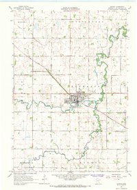
1967 Map of Dawson
USGS Topo · Published 1968About this map
Dawson sits at the confluence of the Lac Qui Parle River and its West Branch, serving as a vital agricultural and transportation hub for western Minnesota in the late 1960s. The town's layout is intricately tied to the Chicago and North Western railroad, which cuts diagonally across the prairie landscape from the northwest. The map reveals an engineered environment where natural watercourses are supplemented by an extensive drainage network, including Judicial Ditch No 4 and Ditch No 27. Cultural markers of the era are visible in the local Cemetery and a Drive-in Theater located just north of the main settlement. Beyond the town limits, the landscape is defined by the rural townships of Hamlin, Riverside, and Maxwell, where numerous Gravel Pits indicate local industry alongside the river's winding path.
Find a feature on this map
20 named features on this map. Tap any name to fly to it.
Don’t see what you’re looking for? This feature index may not catch every label — zoom into the map to look around manually.
Map Details
Editions of this 1967 Dawson Map
This is the sole edition of this map. No revisions or reprints were ever made.
Other maps of this area

1953 · Milbank
USGS Topo · 1:250,000

1953 · Watertown
USGS Topo · 1:250,000

1953 · New Ulm
USGS Topo · 1:250,000

1953 · Saint Cloud
USGS Topo · 1:250,000

1957 · Saint Cloud
USGS Topo · 1:250,000

1957 · New Ulm
USGS Topo · 1:250,000

1958 · New Ulm
USGS Topo · 1:250,000

1958 · Milbank
USGS Topo · 1:250,000

1958 · Watertown
USGS Topo · 1:250,000

1958 · Saint Cloud
USGS Topo · 1:250,000