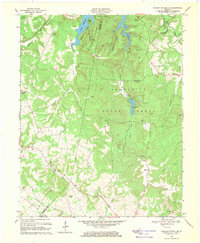
1967 Map of Dawson Springs SW
USGS Topo · Published 1969About this map
Lake Beshear dominates this section of the western Kentucky landscape, its winding fingers filling deep valleys carved by the Tradewater River and its tributaries. The terrain is a complex network of ridges like Orange Ridge and Lisanby Ridge that separate narrow hollows. In the 1960s, this area served as a significant recreational and conservation zone, anchored by the Pennyrile State Forest and the State Park surrounding Pennyrile Lake.
Find a feature on this map
47 named features on this map. Tap any name to fly to it.
Don’t see what you’re looking for? This feature index may not catch every label — zoom into the map to look around manually.
Map Details
Editions of this 1967 Dawson Springs SW Map
2 editions found
Other maps of this area

1908 · Princeton
USGS Topo · 1:62,500

1909 · Dawson Springs
USGS Topo · 1:48,000

1910 · Princeton
USGS Topo · 1:62,500

1911 · Dawson Springs
USGS Topo · 1:62,500

1952 · Pleasant Green Hill
USGS Topo · 1:24,000

1953 · Dawson Springs SE
USGS Topo · 1:24,000

1953 · Gracey
USGS Topo · 1:24,000

1953 · Cobb
USGS Topo · 1:24,000

1953 · Dawson Springs SW
USGS Topo · 1:24,000

1954 · Evansville
USGS Topo · 1:250,000