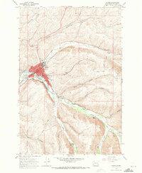
1967 Map of Dayton
USGS Topo · Published 1971About this map
Dayton serves as the focal point of this 1960s survey, situated at the confluence where the Touchet River meets several sprawling drainages including Patit Creek and Mustard Hollow. The town's layout reveals a developed civic core featuring the Courthouse, City Hall, and Hospital, while its industrial identity is defined by the Grain Elevators located along the Union Pacific and Burlington Northern railroad lines. These rail corridors highlight Dayton's role as an agricultural transport hub during this era.
Find a feature on this map
41 named features on this map. Tap any name to fly to it.
Don’t see what you’re looking for? This feature index may not catch every label — zoom into the map to look around manually.
Map Details
Editions of this 1967 Dayton Map
2 editions found
Other maps of this area

1919 · Walla Walla
USGS Topo · 1:125,000

1921 · Walla Walla
USGS Topo · 1:125,000

1937 · Pomeroy
USGS Topo · 1:96,000

1942 · Pomeroy
USGS Topo · 1:125,000

1953 · Walla Walla
USGS Topo · 1:250,000

1955 · Pullman
USGS Topo · 1:250,000

1958 · Pullman
USGS Topo · 1:250,000

1958 · Walla Walla
USGS Topo · 1:250,000
1966 · Coppei
USGS Topo · 1:24,000
1967 · Robinette Mtn.
USGS Topo · 1:24,000