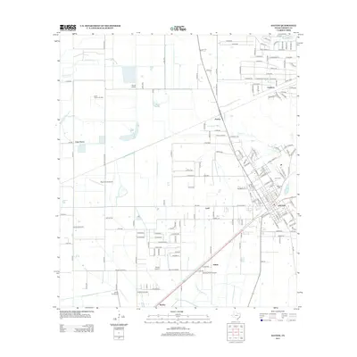
2013 Map of Dayton
USGS Topo · Published 2013About this map
Dayton serves as the primary hub in this Liberty County landscape, where the town's expanding residential grid meets the industrial and agricultural heritage of the Texas coastal plain. The map reveals a high concentration of aviation and energy infrastructure, including the North Dayton Oil Field and Martha Oil Field, alongside several localized airstrips such as Pinoak Airport and West Liberty Airport. These features underscore the region's historical reliance on resource extraction and transport. Waterways like the W Prong Old River and Linney Cr wind through the terrain, defining the local drainage and providing a backdrop for smaller communities. Genealogists will find particular value in the proximity of Linney Cem and Magnolia Cem to the town center, while local historians can trace the smaller outlying settlements of Gum Grove, Ladd, and Stilson, which represent the enduring rural layout of the county.
Find a feature on this map
167 named features on this map. Tap any name to fly to it.
Don’t see what you’re looking for? This feature index may not catch every label — zoom into the map to look around manually.
Map Details
Editions of this 2013 Dayton Map
This is the sole edition of this map. No revisions or reprints were ever made.
Other maps of this area

1916 · Crosby
USGS Topo · 1:24,000

1916 · Huffman
USGS Topo · 1:24,000

1919 · Crosby
USGS Topo · 1:31,680

1920 · Huffman
USGS Topo · 1:31,680

1943 · Liberty
USGS Topo · 1:125,000
1944 · Crosby
USGS Topo · 1:31,680

1950 · Houston
USGS Topo · 1:250,000
1954 · Crosby
USGS Topo · 1:24,000

1954 · Beaumont
USGS Topo · 1:250,000

1955 · Liberty
USGS Topo · 1:62,500