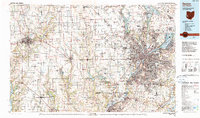
1986 Map of Dayton
USGS Topo · Published 1990About this map
The Great Miami River and its major tributaries, including the Stillwater River and Mad River, define the industrial and urban corridor of southwest Ohio during the mid-1980s. This survey captures the sprawling footprint of Dayton and its satellite communities like Kettering, Beavercreek, and Huber Heights as they expanded along the I-75 and I-70 corridors. The strategic importance of the region is anchored by the massive Wright-Patterson Air Force Base, while the agricultural character of the western reaches is preserved in the grid-like townships of Preble Co and across the state line into Wayne Co, Indiana. Cultural and educational landmarks are prominent, from Miami University in the south to Earlham College in Richmond. Significant recreational and conservation areas such as Hueston Woods State Park and the various Miami Conservancy District reserves illustrate the region's managed landscape and flood control history.
Find a feature on this map
275 named features on this map. Tap any name to fly to it.
Don’t see what you’re looking for? This feature index may not catch every label — zoom into the map to look around manually.
Map Details
Editions of this 1986 Dayton Map
2 editions found
Other maps of this area

1904 · Springfield
USGS Topo · 1:62,500

1904 · Dayton
USGS Topo · 1:62,500

1904 · Mason
USGS Topo · 1:62,500

1905 · Brookville
USGS Topo · 1:62,500

1906 · Dayton
USGS Topo · 1:62,500

1906 · Mason
USGS Topo · 1:62,500

1906 · Springfield
USGS Topo · 1:62,500

1907 · Blanchester
USGS Topo · 1:62,500

1908 · Miamisburg
USGS Topo · 1:62,500

1911 · Covington
USGS Topo · 1:62,500