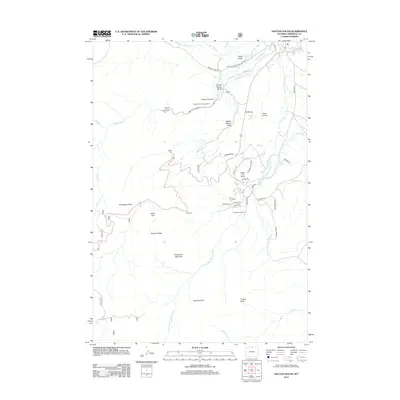
2012 Map of Dayton South
USGS Topo · Published 2012About this map
Tongue River and its various forks carve through the Sheridan County landscape, creating a complex network of canyons and draws. This 2012 survey illustrates the transition from the river valley's agricultural roots at L X Ranch and Horseshoe Ranch to the recreational and geological landmarks of the foothills. Distinctive landforms such as Steamboat Point, Fallen City, and Elephant Foot dominate the terrain, while the Tongue Canyon Campground serves as a modern focal point for visitors. The map also documents the development of private aviation through the Xingu Airstrip and a winding residential network near Bulls Eye Point. Hydrological features like the South Side Ditch and Frisbie Ditch reveal the long-standing management of water in this part of Wyoming, supporting both ranching and the newer homesteads along the eastern slopes.
Find a feature on this map
54 named features on this map. Tap any name to fly to it.
Don’t see what you’re looking for? This feature index may not catch every label — zoom into the map to look around manually.
Map Details
Editions of this 2012 Dayton South Map
This is the sole edition of this map. No revisions or reprints were ever made.
Other maps of this area

1895 · Dayton
USGS Topo · 1:125,000

1901 · Dayton
USGS Topo · 1:125,000

1955 · Sheridan
USGS Topo · 1:250,000

1958 · Sheridan
USGS Topo · 1:250,000

1962 · Sheridan
USGS Topo · 1:250,000

1964 · Wolf
USGS Topo · 1:24,000
1964 · Ranchester
USGS Topo · 1:24,000
1964 · Dayton North
USGS Topo · 1:24,000

1964 · Dayton South
USGS Topo · 1:24,000
1964 · Skull Ridge
USGS Topo · 1:24,000