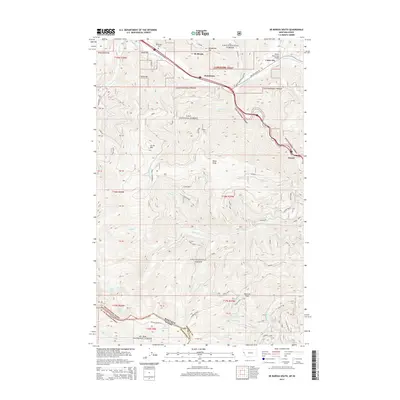
2014 Map of De Borgia South
USGS Topo · Published 2014About this map
Saint Regis River valley settlements define the northern corridor of this landscape, where the small communities of De Borgia, Henderson, and Cabin City are situated. The northern half of the map is shaped by human infrastructure and mountain access, featuring the De Borgia Cem and the Twelve Mile Creek Bridge. To the south, the terrain rises into the high country of the Lolo National Forest, where peaks like Up Up Mtn, Moon Peak, and Newman Peak dominate the topography. This transition from river-bottom settlements to high-elevation forest highlights the importance of the valley as a primary passage through the mountains. Remote water bodies like Hazel Lake, Hub Lake, and Lenore Lake are tucked into the high basins near the border of the St Joe National Forest and the Shoshone Co line.
Find a feature on this map
48 named features on this map. Tap any name to fly to it.
Don’t see what you’re looking for? This feature index may not catch every label — zoom into the map to look around manually.
Map Details
Editions of this 2014 De Borgia South Map
This is the sole edition of this map. No revisions or reprints were ever made.
Other maps of this area

1918 · St Regis
USGS Topo · 1:125,000

1919 · St. Regis
USGS Topo · 1:125,000

1956 · St Regis
USGS Topo · 1:62,500

1956 · Wallace
USGS Topo · 1:250,000

1957 · Illinois Peak
USGS Topo · 1:62,500

1957 · Haugan
USGS Topo · 1:62,500

1957 · Simmons Peak
USGS Topo · 1:62,500

1960 · Wallace
USGS Topo · 1:250,000
1988 · Torino Peak
USGS Topo · 1:24,000
1988 · Penrose Peak
USGS Topo · 1:24,000