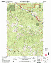
1999 Map of De Borgia South
USGS Topo · Published 2003About this map
De Borgia and the small settlements of Henderson and Cabin City occupy the narrow northern corridor of this 1999 survey, where the St Regis River carves a path through the Bitterroot Mountains. The map documents a landscape defined by sharp elevation changes and the heavy influence of the Lolo National Forest and St Joe National Forest. High-altitude landmarks like the Up Up Mountain Lookout and Moon Peak overlook a network of drainages including Ward Creek and Cedar Creek. For researchers of industrial history, the sheet identifies the Aladdin Mine and various adits nestled in the southern slopes, while the eastern edge notes the Drexel (Site). This edition reflects the late 20th-century state of these mountain passes along the Montana and Idaho border, capturing the relationship between high mountain lakes like Hub Lake and the rugged watersheds below.
Find a feature on this map
35 named features on this map. Tap any name to fly to it.
Don’t see what you’re looking for? This feature index may not catch every label — zoom into the map to look around manually.
Map Details
Editions of this 1999 De Borgia South Map
This is the sole edition of this map. No revisions or reprints were ever made.
Other maps of this area

1918 · St Regis
USGS Topo · 1:125,000

1919 · St. Regis
USGS Topo · 1:125,000

1956 · St Regis
USGS Topo · 1:62,500

1956 · Wallace
USGS Topo · 1:250,000

1957 · Illinois Peak
USGS Topo · 1:62,500

1957 · Haugan
USGS Topo · 1:62,500

1957 · Simmons Peak
USGS Topo · 1:62,500

1960 · Wallace
USGS Topo · 1:250,000
1988 · Torino Peak
USGS Topo · 1:24,000
1988 · Penrose Peak
USGS Topo · 1:24,000