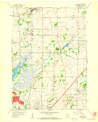
1959 Map of De Forest
USGS Topo · Published 1960About this map
De Forest and the surrounding township of Windsor reflect a mid-century agricultural landscape on the verge of suburban expansion toward the city of Madison. The map is punctuated by an exceptional concentration of rural schoolhouses, such as Wangsness Sch, Vincent Sch, and Wilcox Sch, signaling the persistence of localized education districts even as larger hubs like Windsor began to consolidate. Along the southern edge, the extensive footprint of Truax Field and nearby developments like Reindahl Park mark the urban-rural interface.
Find a feature on this map
49 named features on this map. Tap any name to fly to it.
Don’t see what you’re looking for? This feature index may not catch every label — zoom into the map to look around manually.
Map Details
Editions of this 1959 De Forest Map
3 editions found
Other maps of this area

1890 · Madison
USGS Topo · 1:62,500

1890 · Sun Prairie
USGS Topo · 1:62,500

1892 · Madison
USGS Topo · 1:62,500

1896 · Sun Prairie
USGS Topo · 1:62,500

1901 · Poynette
USGS Topo · 1:62,500

1904 · Madison
USGS Topo · 1:62,500

1905 · Sun Prairie
USGS Topo · 1:62,500

1906 · Madison
USGS Topo · 1:62,500

1907 · Sun Prairie
USGS Topo · 1:62,500

1955 · Columbus
USGS Topo · 1:62,500