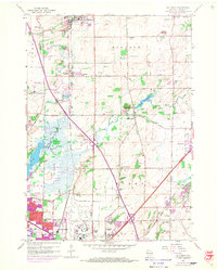
1959 Map of De Forest
USGS Topo · Published 1970About this map
Truax Field and the expanding northern edge of Madison anchor this mid-century survey of Dane County. The landscape is a mix of agricultural heritage and emerging suburban development, particularly evident in the purple-tinted growth around De Forest and Sun Prairie. Numerous rural one-room schoolhouses, such as Pumpkin Hollow Sch and Wangsness Sch, remain as indicators of the area's earlier district organization, while several church-affiliated sites like Norway Grove Ch and the Burke Ch Cem suggest established immigrant communities.
Find a feature on this map
53 named features on this map. Tap any name to fly to it.
Don’t see what you’re looking for? This feature index may not catch every label — zoom into the map to look around manually.
Map Details
Editions of this 1959 De Forest Map
3 editions found
Other maps of this area

1890 · Madison
USGS Topo · 1:62,500

1890 · Sun Prairie
USGS Topo · 1:62,500

1892 · Madison
USGS Topo · 1:62,500

1896 · Sun Prairie
USGS Topo · 1:62,500

1901 · Poynette
USGS Topo · 1:62,500

1904 · Madison
USGS Topo · 1:62,500

1905 · Sun Prairie
USGS Topo · 1:62,500

1906 · Madison
USGS Topo · 1:62,500

1907 · Sun Prairie
USGS Topo · 1:62,500

1955 · Columbus
USGS Topo · 1:62,500