
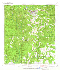
1935 Map of De Funiak Springs
USGS Topo · Published 1935About this map
De Funiak Springs serves as the focal point of this 1935 survey, situated along the Louisville and Nashville railroad and the Old Spanish Trail. The map documents a rural Florida landscape transitioning into the early aviation era, evidenced by the De Funiak Springs Landing Field and the De Funiak Country Club. To the north and west, the terrain rises toward Alpine Heights and Bear Head, while the southern reaches are defined by the Tallahassee Base Line and the winding course of Alaqua Creek. Local social life is mapped through several country schools like Indian Head Sch and Macedonia Sch, alongside community anchors like Magnolia Ch and the Magnolia Cem. The inclusion of Seckinger Mill and various named homesteads like Blount Place provides a detailed look at the scattered rural settlement patterns of Walton County before the mid-century expansion.
Find a feature on this map
41 named features on this map. Tap any name to fly to it.
Don’t see what you’re looking for? This feature index may not catch every label — zoom into the map to look around manually.
Map Details
Editions of this 1935 De Funiak Springs Map
2 editions found
Other maps of this area

1934 · Niceville
USGS Topo · 1:48,000

1935 · Villa Tasso
USGS Topo · 1:48,000

1936 · Niceville
USGS Topo · 1:62,500

1936 · Point Washington
USGS Topo · 1:48,000

1938 · Villa Tasso
USGS Topo · 1:62,500

1938 · De Funiak Springs
USGS Topo · 1:62,500

1939 · Point Washington
USGS Topo · 1:62,500

1944 · Bruce
USGS Topo · 1:24,000

1945 · Bruce
USGS Topo · 1:31,680

1948 · Ponce De Leon
USGS Topo · 1:24,000