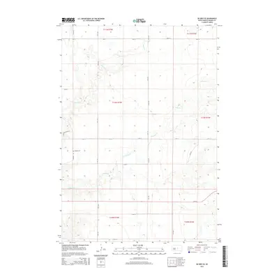
2015 Map of De Grey SE
USGS Topo · Published 2015About this map
Chapelle Cr and its southern branch, S Chapelle Cr, carve a complex drainage system through this high plains landscape of Hughes County. The terrain is defined by the sharp rise of Scattergun Ridge Rd and a strict grid of section-line roads, including 212th St and 318th Ave, which partition the vast agricultural and ranching tracts. This 2015 survey reveals the sparse settlement pattern characteristic of the Big Bend District, where the historic Chapelle Cem stands as a primary landmark for local genealogy. The map provides an essential look at the modern land management within Townships 109, 110, and 111 North, documenting the intersection of natural watercourses and the persistent human imprint of the Public Land Survey System.
Find a feature on this map
24 named features on this map. Tap any name to fly to it.
Don’t see what you’re looking for? This feature index may not catch every label — zoom into the map to look around manually.
Map Details
Editions of this 2015 De Grey SE Map
This is the sole edition of this map. No revisions or reprints were ever made.
Other maps of this area

1953 · Huron
USGS Topo · 1:250,000

1954 · Huron
USGS Topo · 1:250,000

1966 · Lower Brule NW
USGS Topo · 1:24,000

1966 · Joe Creek
USGS Topo · 1:24,000

1966 · Joe Creek NW
USGS Topo · 1:24,000

1967 · De Grey NE
USGS Topo · 1:24,000
1967 · De Grey NW
USGS Topo · 1:24,000

1973 · De Grey SE
USGS Topo · 1:24,000
1973 · De Grey
USGS Topo · 1:24,000

1973 · Chapelle Lake SW
USGS Topo · 1:24,000