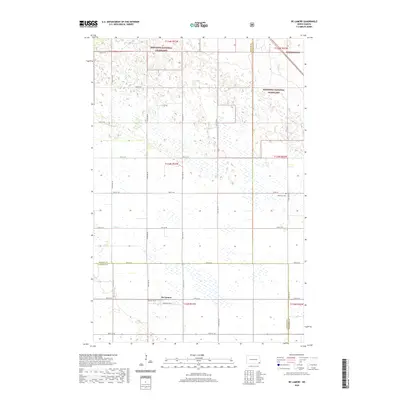
2020 Map of De Lamere
USGS Topo · Published 2020About this map
Sheyenne National Grassland dominates the northern portion of this landscape, where the prairie transitions into a complex pattern of wetlands and low-lying depressions. The small community of De Lamere sits along the southern edge of this grid, defined by a cluster of residential streets and thoroughfares like Pacific Ave W and Broadway Ave E. This 2020 survey illustrates the intersection of three counties—Ransom, Richland, and Sargent—reflecting a rural North Dakota environment where land use is split between protected grasslands and agricultural plots. The inclusion of Anderson Cem and the seasonal path of Elk Cr provides specific coordinates for genealogists and local historians tracing the heritage of this sparsely populated prairie region.
Find a feature on this map
25 named features on this map. Tap any name to fly to it.
Don’t see what you’re looking for? This feature index may not catch every label — zoom into the map to look around manually.
Map Details
Editions of this 2020 De Lamere Map
This is the sole edition of this map. No revisions or reprints were ever made.
Other maps of this area

1907 · Wyndmere
USGS Topo · 1:125,000

1953 · Fargo
USGS Topo · 1:250,000

1956 · Fargo
USGS Topo · 1:250,000

1958 · Cayuga NW
USGS Topo · 1:24,000

1958 · Hamlin
USGS Topo · 1:24,000

1960 · Wyndmere
USGS Topo · 1:24,000

1960 · Wyndmere NW
USGS Topo · 1:24,000

1960 · De Lamere
USGS Topo · 1:24,000

1960 · Venlo
USGS Topo · 1:24,000

1960 · Milnor
USGS Topo · 1:24,000
Featured Places
- Went End Township, ND
- Wyndmere Township, ND
- Rosemeade Township, ND
- Freeman Township, ND
- Hall Township, ND