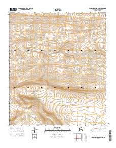
2015 Map of De Long Mountains D-1 NW
USGS Topo · Published 2015About this map
Tupikehak Cr winds through the high-elevation landscape of the De Long Mountains in this 2015 survey of the Alaska North Slope. The terrain is defined by steep contour intervals that illustrate the drainage patterns of the western Arctic. Public Land Survey System boundaries, including t5s r45w and t6s r44w, divide the remote interior, showing the systematic grid established by the Bureau of Land Management across these northern reaches. This map serves as a precise record of the topography and hydrology in a region largely untouched by modern infrastructure, focusing on the natural watercourses that have shaped the land for generations.
Find a feature on this map
5 named features on this map. Tap any name to fly to it.
Don’t see what you’re looking for? This feature index may not catch every label — zoom into the map to look around manually.
Map Details
Editions of this 2015 De Long Mountains D-1 NW Map
This is the sole edition of this map. No revisions or reprints were ever made.
Other maps of this area

1951 · De Long Mountains
USGS Topo · 1:250,000

1951 · Point Lay
USGS Topo · 1:250,000

1955 · De Long Mountains
USGS Topo · 1:250,000

1955 · Point Lay
USGS Topo · 1:250,000

1955 · Point Lay A-1
USGS Topo · 1:63,360

1955 · De Long Mountains D-2
USGS Topo · 1:63,360
1955 · De Long Mountains D-1
USGS Topo · 1:63,360
1955 · Point Lay A-2
USGS Topo · 1:63,360
1956 · Point Lay A-2
USGS Topo · 1:63,360

1965 · Point Lay
USGS Topo · 1:250,000