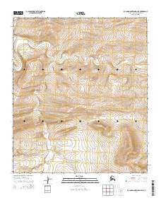
2014 Map of De Long Mountains D-2 NE
USGS Topo · Published 2014About this map
Kukpowruk River defines the western edge of this Arctic landscape, where the terrain transitions into a series of drainages in the De Long Mountains. The area is characterized by the convergence of several waterways, including the winding Tupikchak Cr and Surprise Cr, which cut through the North Slope's complex topography. This 2014 survey documents the remote northern reaches of Alaska, illustrating the natural hydrological patterns across the township boundaries of t5s r46w and t6s r46w. The lack of man-made infrastructure or settlements underscores the untouched character of this wilderness during the early 21st century.
Find a feature on this map
7 named features on this map. Tap any name to fly to it.
Don’t see what you’re looking for? This feature index may not catch every label — zoom into the map to look around manually.
Map Details
Editions of this 2014 De Long Mountains D-2 NE Map
This is the sole edition of this map. No revisions or reprints were ever made.
Other maps of this area

1951 · De Long Mountains
USGS Topo · 1:250,000

1951 · Point Lay
USGS Topo · 1:250,000

1955 · De Long Mountains
USGS Topo · 1:250,000

1955 · Point Lay
USGS Topo · 1:250,000

1955 · Point Lay A-1
USGS Topo · 1:63,360

1955 · De Long Mountains D-2
USGS Topo · 1:63,360
1955 · De Long Mountains D-1
USGS Topo · 1:63,360
1955 · Point Lay A-2
USGS Topo · 1:63,360
1956 · Point Lay A-2
USGS Topo · 1:63,360

1965 · Point Lay
USGS Topo · 1:250,000