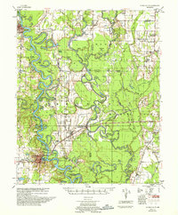
1957 Map of De Valls Bluff
USGS Topo · Published 1957About this map
White River and Cache River dominate this landscape, their meandering courses creating a complex network of oxbow lakes, sloughs, and islands across Prairie, Woodruff, and Monroe counties. The mid-century river economy is evident in the numerous levees, revetments, and river gages mapped by the Mississippi River Commission and the U.S. Army Corps of Engineers. Settlement is concentrated along the higher ground and major transport corridors, notably where the Chicago Rock Island And Pacific and ST Louis Southwestern railroads bridge the river bottoms near De Valls Bluff and Biscoe. These lines connect smaller rail stops like Mesa and Brasfield. The map reveals the rural social fabric through legacy sites like St. Johns Cem, Mt. Pleasant Ch & Sch, and Ash Grove Ch & Cem, while the conservation areas of the Dagmar Game Refuge occupy the wetlands between the rivers.
Find a feature on this map
113 named features on this map. Tap any name to fly to it.
Don’t see what you’re looking for? This feature index may not catch every label — zoom into the map to look around manually.
Map Details
Editions of this 1957 De Valls Bluff Map
This is the sole edition of this map. No revisions or reprints were ever made.
Other maps of this area

1932 · Kensett
USGS Topo · 1:62,500

1935 · Kensett
USGS Topo · 1:62,500

1935 · Hazen
USGS Topo · 1:62,500

1935 · Clarendon
USGS Topo · 1:62,500

1935 · Gregory
USGS Topo · 1:62,500

1937 · Stuttgart
USGS Topo · 1:62,500

1939 · Hunter
USGS Topo · 1:62,500

1939 · Stuttgart
USGS Topo · 1:62,500

1940 · Holly Grove
USGS Topo · 1:62,500

1940 · Brinkley
USGS Topo · 1:62,500