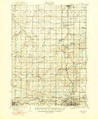
1927 Map of De Witt
USGS Topo · Published 1950About this map
St Johns and the surrounding Clinton County agricultural landscape dominate this mid-1920s survey, characterized by a dense grid of rural schoolhouses and family farms. The map reveals an era when local education was decentralized, as evidenced by nearly two dozen named schools like the Bengal Center School, Stony Creek School, and Cramer School spaced evenly throughout the townships of Bengal and Bingham. The Lookingglass River meanders across the central portion, connecting small communities such as De Witt and Wacousta.
Find a feature on this map
88 named features on this map. Tap any name to fly to it.
Don’t see what you’re looking for? This feature index may not catch every label — zoom into the map to look around manually.
Map Details
Editions of this 1927 De Witt Map
3 editions found
Other maps of this area

1909 · Mason
USGS Topo · 1:62,500

1910 · Lansing
USGS Topo · 1:62,500

1911 · Mason
USGS Topo · 1:62,500

1912 · Lansing
USGS Topo · 1:62,500

1918 · Elsie
USGS Topo · 1:62,500

1918 · Perrinton
USGS Topo · 1:62,500

1927 · De Witt
USGS Topo · 1:62,500

1928 · Laingsburg
USGS Topo · 1:62,500

1943 · Perrinton
USGS Topo · 1:62,500

1943 · Elsie
USGS Topo · 1:62,500