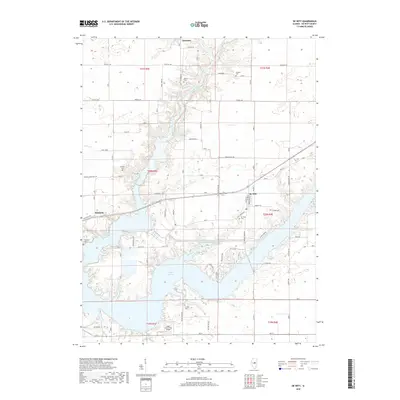
2018 Map of De Witt
USGS Topo · Published 2018About this map
Lake Clinton dominates the southern landscape of this DeWitt County region, where the sprawling reservoir meets the winding course of the North Fork Salt Creek. The village of De Witt sits at a crossroads near the water's edge, serving as a focal point for a rural landscape defined by agricultural sections and scattered family cemeteries. Traces of early settlement are evident at Solomon and Birkbeck, while several historic burial grounds, including Johnson Cem, Griffith Cem, and Lisenby Cem, are preserved among the fields. The presence of the Sugar Hollow RLA Airport and smaller water bodies like Lake Shineman and Carter Pond illustrate the modern intersection of recreation and local aviation within this traditional Central Illinois farming community.
Find a feature on this map
40 named features on this map. Tap any name to fly to it.
Don’t see what you’re looking for? This feature index may not catch every label — zoom into the map to look around manually.
Map Details
Editions of this 2018 De Witt Map
This is the sole edition of this map. No revisions or reprints were ever made.
Other maps of this area

1937 · Monticello
USGS Topo · 1:48,000

1943 · Monticello
USGS Topo · 1:62,500

1951 · Le Roy
USGS Topo · 1:62,500

1952 · Arrowsmith
USGS Topo · 1:62,500

1957 · Maroa
USGS Topo · 1:62,500

1958 · Peoria
USGS Topo · 1:250,000

1961 · Peoria
USGS Topo · 1:250,000

1963 · Peoria
USGS Topo · 1:250,000
1979 · Maroa
USGS Topo · 1:24,000

1979 · De Witt
USGS Topo · 1:24,000