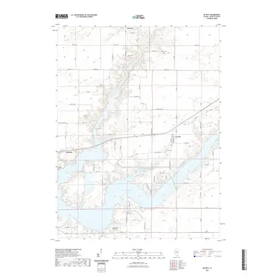
2021 Map of De Witt
USGS Topo · Published 2021About this map
Lake Clinton dominates the southern half of this DeWitt County landscape, its winding shoreline creating a complex pattern of peninsulas and inlets that define the modern geography. The village of De Witt is situated just north of the lake’s eastern reaches, serving as a central hub for a network of country roads including Market RD and Old Clinton RD. To the west, the small community of Birkbeck stands near the headwaters of local drainages, while the northern terrain is marked by the small settlement of Solomon. This area preserves a high density of small family and community burial grounds, such as Walters Cem, Johnson Cem, and Griffith Cem, which offer significant value for genealogical research. The northern portion of the map is drained by the North Fork Salt Creek, which feeds into the larger reservoir system. Recreational and utility infrastructure is evident through the Sugar Hollow RLA Airport and the managed waters of Clinton Anglers Lakes.
Find a feature on this map
30 named features on this map. Tap any name to fly to it.
Don’t see what you’re looking for? This feature index may not catch every label — zoom into the map to look around manually.
Map Details
Editions of this 2021 De Witt Map
This is the sole edition of this map. No revisions or reprints were ever made.
Other maps of this area

1937 · Monticello
USGS Topo · 1:48,000

1943 · Monticello
USGS Topo · 1:62,500

1951 · Le Roy
USGS Topo · 1:62,500

1952 · Arrowsmith
USGS Topo · 1:62,500

1957 · Maroa
USGS Topo · 1:62,500

1958 · Peoria
USGS Topo · 1:250,000

1961 · Peoria
USGS Topo · 1:250,000

1963 · Peoria
USGS Topo · 1:250,000
1979 · Maroa
USGS Topo · 1:24,000

1979 · De Witt
USGS Topo · 1:24,000