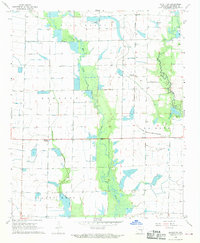
1968 Map of De Witt SW
USGS Topo · Published 1970About this map
The agricultural landscape of Arkansas County is defined here by the intricate drainage systems of Mill Bayou, Hurricane Bayou, and the broad Bayou Meto. This 1960s survey documents a region dominated by rice farming and waterfowl habitat, where seasonal flooding is managed through a complex network of flumes, siphons, and wells. Small rural communities like Kittlers, Olena, and Burks serve as local hubs along the St Louis Southwestern railroad line, while Eldridge Corner sits at a prominent crossroads. The map reveals the transition between cultivated fields and the wooded wetlands of the La Grue and Garland townships, including distinct features like Hillman Pond and a small Landing Strip. These details illustrate the mid-century intersection of the Grand Prairie’s natural hydrology with intensive irrigation and rail-based transport.
Find a feature on this map
15 named features on this map. Tap any name to fly to it.
Don’t see what you’re looking for? This feature index may not catch every label — zoom into the map to look around manually.
Map Details
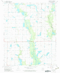
Editions of this 1968 De Witt SW Map
2 editions found
Other maps of this area

1935 · Varner
USGS Topo · 1:62,500

1935 · Gillett
USGS Topo · 1:62,500

1941 · De Witt
USGS Topo · 1:62,500

1941 · Goldman
USGS Topo · 1:62,500

1948 · Helena
USGS Topo · 1:250,000

1950 · Helena
USGS Topo · 1:250,000

1954 · De Witt
USGS Topo · 1:62,500

1955 · Helena
USGS Topo · 1:250,000

1959 · Helena
USGS Topo · 1:250,000

1960 · Helena
USGS Topo · 1:250,000