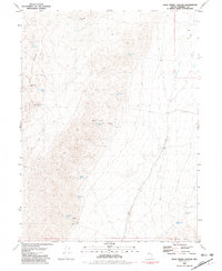
1981 Map of Dead Horse Canyon
USGS Topo · Published 1981About this map
Windy Hill Mine and a scatter of prospects sit at the northern edge of the Seven Troughs Range, marking the persistence of mining interest in this arid Pershing County landscape. The terrain is defined by dramatic geological features, including the stark expanses of The Lava Beds and isolated formations like Elephant Head Rock.
Find a feature on this map
46 named features on this map. Tap any name to fly to it.
Don’t see what you’re looking for? This feature index may not catch every label — zoom into the map to look around manually.
Map Details
Editions of this 1981 Dead Horse Canyon Map
This is the sole edition of this map. No revisions or reprints were ever made.
Other maps of this area

1886 · Granite Range
USGS Topo · 1:250,000

1894 · Granite Range
USGS Topo · 1:250,000

1931 · Lovelock
USGS Topo · 1:250,000

1935 · Lovelock
USGS Topo · 1:250,000

1955 · Lovelock
USGS Topo · 1:250,000

1959 · Lovelock
USGS Topo · 1:250,000

1980 · Eagle Rock Spring
USGS Topo · 1:24,000

1980 · Dry Mountain
USGS Topo · 1:24,000
1981 · Sheep Spring
USGS Topo · 1:24,000

1981 · Twin Buttes Well
USGS Topo · 1:24,000