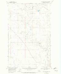
1968 Map of Dead Indian Spring
USGS Topo · Published 1972About this map
The arid drainage patterns of the Blackfeet Indian Reservation characterize this late-1960s landscape, defined by seasonal water sources and expansive range. Big Rock Coulee and Little Rock Coulee wind through the terrain, punctuated by vital water points like Dead Indian Spring and Coyote Springs. The presence of a Pumping Sta and scattered Gravel Pits reflects the minimal but essential industrial infrastructure required to support operations in this high-plains environment. Significant topographic features like Dripping Hole Spring and the East Fork provide a glimpse into the natural hydration network that historically dictated movement across these northern Montana grasslands. This map captures a moment when the land remained largely open, marked primarily by section lines and the natural contours of the coulees.
Find a feature on this map
9 named features on this map. Tap any name to fly to it.
Don’t see what you’re looking for? This feature index may not catch every label — zoom into the map to look around manually.
Map Details
Editions of this 1968 Dead Indian Spring Map
This is the sole edition of this map. No revisions or reprints were ever made.
Other maps of this area

1907 · Blackfoot Res.
USGS Topo · 1:48,000

1909 · Cut Bank
USGS Topo · 1:125,000

1911 · Blackfoot
USGS Topo · 1:125,000

1912 · Cut Bank
USGS Topo · 1:125,000

1960 · Cut Bank
USGS Topo · 1:250,000

1963 · Cut Bank
USGS Topo · 1:250,000

1964 · Cut Bank
USGS Topo · 1:250,000
1966 · Cut Bank
USGS Topo · 1:24,000
1966 · Gunsight
USGS Topo · 1:24,000

1968 · Headlight Butte NE
USGS Topo · 1:24,000