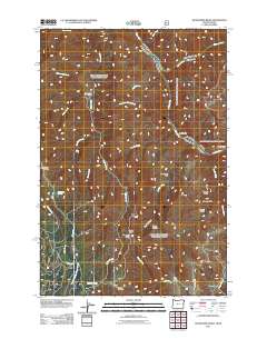
2011 Map of Deadhorse Ridge
USGS Topo · Published 2011About this map
The Snake River and Salmon River converge in this high-elevation corner of Idaho and Oregon, defining a landscape of deep canyons and isolated outposts. Long-established cattle operations and seasonal shelters like the Cherry Creek Ranch, Tulley Creek Ranch, and Eureka Creek Cabin are positioned along the primary waterways, while the Buckhorn Lookout provides a vantage point over the southern reaches of the quadrangle. High ridges and deep gulches dictate the movement of roads, such as Buckhorn Rd and Nat For Dev Rd 760, which wind through the drainage of the South Fork Chesnimnus Creek. The naming of features like Cemetery Ridge, Deadhorse Ridge, and Spain Saddle reflects the heritage of early ranching and travel through this confluence region, where the Imnaha River also joins the Snake at the edge of Eureka Bar.
Find a feature on this map
36 named features on this map. Tap any name to fly to it.
Don’t see what you’re looking for? This feature index may not catch every label — zoom into the map to look around manually.
Map Details
Editions of this 2011 Deadhorse Ridge Map
This is the sole edition of this map. No revisions or reprints were ever made.
Other maps of this area

1954 · Imnaha
USGS Topo · 1:62,500

1954 · Kernan Point
USGS Topo · 1:62,500

1955 · Grangeville
USGS Topo · 1:250,000

1959 · Grangeville
USGS Topo · 1:250,000

1963 · Cactus Mtn
USGS Topo · 1:24,000

1963 · Deadhorse Ridge
USGS Topo · 1:24,000

1963 · Jim Creek Butte
USGS Topo · 1:24,000

1963 · Rattlesnake Ridge
USGS Topo · 1:24,000

1963 · Wapshilla Creek
USGS Topo · 1:24,000

1963 · Poison Point
USGS Topo · 1:24,000