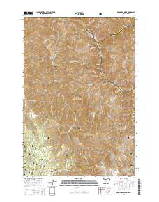
2014 Map of Deadhorse Ridge
USGS Topo · Published 2014About this map
The Snake River carves a deep path through this borderland where Oregon and Idaho meet, joined at the northern edge by the Salmon River. This high-elevation terrain is defined by dramatic vertical relief, from the low-lying Eureka Bar on the riverbank to the soaring heights of Craig Mtn and Wapshilla Ridge. The landscape is largely contained within the Wallowa National Forest, where steep canyons and narrow draws like Toomey Gulch and Vance Draw drain into the primary river systems.
Find a feature on this map
44 named features on this map. Tap any name to fly to it.
Don’t see what you’re looking for? This feature index may not catch every label — zoom into the map to look around manually.
Map Details
Editions of this 2014 Deadhorse Ridge Map
This is the sole edition of this map. No revisions or reprints were ever made.
Other maps of this area

1954 · Imnaha
USGS Topo · 1:62,500

1954 · Kernan Point
USGS Topo · 1:62,500

1955 · Grangeville
USGS Topo · 1:250,000

1959 · Grangeville
USGS Topo · 1:250,000

1963 · Cactus Mtn
USGS Topo · 1:24,000

1963 · Deadhorse Ridge
USGS Topo · 1:24,000

1963 · Jim Creek Butte
USGS Topo · 1:24,000

1963 · Rattlesnake Ridge
USGS Topo · 1:24,000

1963 · Wapshilla Creek
USGS Topo · 1:24,000

1963 · Poison Point
USGS Topo · 1:24,000