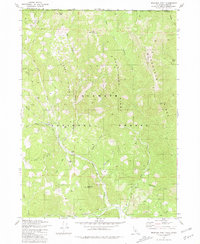
1981 Map of Deadman Point
USGS Topo · Published 1981About this map
Klamath National Forest defines this mountainous borderland where the Pacific Northwest meets Northern California. The 1981 terrain is defined by its extraction history, with several notable claims such as the Classic Hill Mine, County Mine, and Wood Mine scattered among the steep drainages of Indian Creek and Thompson Creek. Significant elevation changes are marked by Mill Creek Ridge and Thompson Ridge, rising toward peaks like Spees Peak and Bare Mountain. Local administrative presence is found at the West Branch FS Station, situated near a campground along West Branch Grayback Creek. This map is a record of an era when resource roads and four-wheel-drive trails provided the primary access for prospecting and forestry in the Siskiyou mountains, showing a landscape of deep gulches including Wagner Gulch and Swearingen Gulch.
Find a feature on this map
39 named features on this map. Tap any name to fly to it.
Don’t see what you’re looking for? This feature index may not catch every label — zoom into the map to look around manually.
Map Details
Editions of this 1981 Deadman Point Map
3 editions found
Other maps of this area

1908 · Grants Pass
USGS Topo · 1:125,000

1914 · Seiad
USGS Topo · 1:125,000

1917 · Kerby
USGS Topo · 1:125,000

1918 · Kerby
USGS Topo · 1:125,000

1922 · Preston Peak
USGS Topo · 1:125,000

1922 · Seiad
USGS Topo · 1:125,000

1945 · Kerby
USGS Topo · 1:125,000

1948 · Weed
USGS Topo · 1:250,000

1950 · Weed
USGS Topo · 1:250,000

1954 · Cave Junction
USGS Topo · 1:62,500