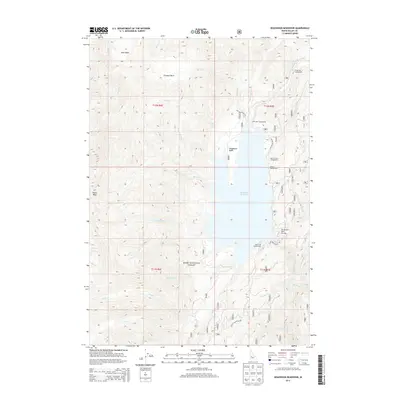
2013 Map of Deadwood Reservoir
USGS Topo · Published 2013About this map
Deadwood Reservoir dominates this high-elevation landscape within the Boise National Forest, serving as a central hub for recreational access in Valley County. The 2013 survey illustrates the extensive network of national forest development roads, such as Nat For Dev Rd 555, which connect various remote sites along the shoreline. Recreational use is well-documented through a series of established locations including Fir Springs Campground, Cozy Cove Campground, and Homers Campground.
Find a feature on this map
37 named features on this map. Tap any name to fly to it.
Don’t see what you’re looking for? This feature index may not catch every label — zoom into the map to look around manually.
Map Details
Editions of this 2013 Deadwood Reservoir Map
This is the sole edition of this map. No revisions or reprints were ever made.
Other maps of this area

1909 · Garden Valley
USGS Topo · 1:125,000

1953 · Boiling Springs
USGS Topo · 1:62,500

1953 · Deadwood Reservoir
USGS Topo · 1:62,500

1957 · Challis
USGS Topo · 1:250,000

1959 · Garden Valley
USGS Topo · 1:62,500

1960 · Challis
USGS Topo · 1:250,000

1963 · Challis
USGS Topo · 1:250,000

1972 · Scott Creek
USGS Topo · 1:24,000
1972 · Miller Mtn West
USGS Topo · 1:24,000

1982 · Deadwood River
USGS Topo · 1:100,000