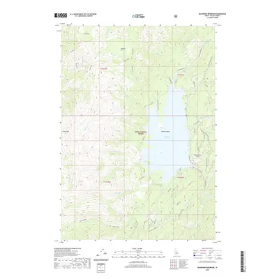
2020 Map of Deadwood Reservoir
USGS Topo · Published 2020About this map
Deadwood Reservoir serves as the central focal point of this mountainous region within the Boise National Forest. The 2020 landscape is defined by the engineering of the Deadwood Dam and the associated Deadwood Admin Site, which manage the flow of the Deadwood River south through the Deadwood Basin. This modern topographic study reveals a rugged geography marked by high-elevation basins such as Ucon Basin, Tranquil Basin, and Whitehawk Basin. A network of backcountry routes, including the Bummer Creek Jeep Trail and the Westside road, provides access to the shoreline and surrounding ridges. The inclusion of a remote Airstrip near the dam highlights the infrastructure required for managing this high-country water system and its surrounding timberlands.
Find a feature on this map
46 named features on this map. Tap any name to fly to it.
Don’t see what you’re looking for? This feature index may not catch every label — zoom into the map to look around manually.
Map Details
Editions of this 2020 Deadwood Reservoir Map
This is the sole edition of this map. No revisions or reprints were ever made.
Other maps of this area

1909 · Garden Valley
USGS Topo · 1:125,000

1953 · Boiling Springs
USGS Topo · 1:62,500

1953 · Deadwood Reservoir
USGS Topo · 1:62,500

1957 · Challis
USGS Topo · 1:250,000

1959 · Garden Valley
USGS Topo · 1:62,500

1960 · Challis
USGS Topo · 1:250,000

1963 · Challis
USGS Topo · 1:250,000

1972 · Scott Creek
USGS Topo · 1:24,000
1972 · Miller Mtn West
USGS Topo · 1:24,000

1982 · Deadwood River
USGS Topo · 1:100,000