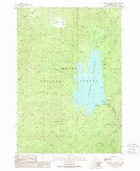
1988 Map of Deadwood Reservoir
USGS Topo · Published 1988About this map
Deadwood Reservoir dominates the heart of the Boise National Forest in this late-1980s topographic study. The landscape is defined by the impounded Deadwood River, which flows into the reservoir from the northeast and continues south from the spillway near the Lower Deadwood F S Station. Remote recreation is a primary theme of the era, as evidenced by several shoreline facilities including Cozy Cove Campground, Riverside Campground, and Homers Campground. To the west, the terrain rises sharply from the water's edge into high mountain basins such as Ucon Basin and Tranquil Basin. The drainage network is dense with named tributaries like Habit Creek, Moulding Creek, and Bummer Creek. A network of unmaintained routes and the Pack Trail suggest a landscape navigated more by foot or pack animal than modern motor vehicles.
Find a feature on this map
26 named features on this map. Tap any name to fly to it.
Don’t see what you’re looking for? This feature index may not catch every label — zoom into the map to look around manually.
Map Details
Editions of this 1988 Deadwood Reservoir Map
This is the sole edition of this map. No revisions or reprints were ever made.
Other maps of this area

1909 · Garden Valley
USGS Topo · 1:125,000

1953 · Boiling Springs
USGS Topo · 1:62,500

1953 · Deadwood Reservoir
USGS Topo · 1:62,500

1957 · Challis
USGS Topo · 1:250,000

1959 · Garden Valley
USGS Topo · 1:62,500

1960 · Challis
USGS Topo · 1:250,000

1963 · Challis
USGS Topo · 1:250,000

1972 · Scott Creek
USGS Topo · 1:24,000
1972 · Miller Mtn West
USGS Topo · 1:24,000

1982 · Deadwood River
USGS Topo · 1:100,000